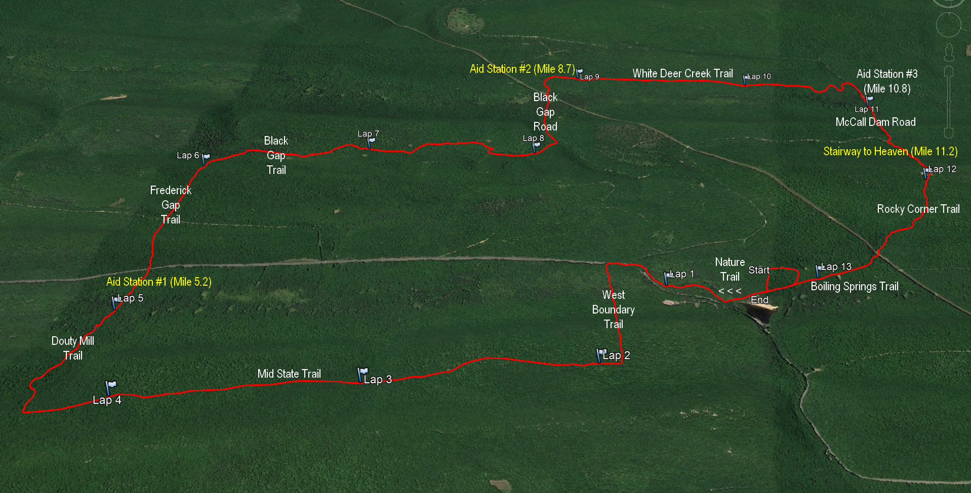
The Dam Half course is situated within Bald Eagle State Forest, and you really
get the feeling of being far from civilization when
doing this course! Mostly narrow single track trails with some
jeep trails and a little bit of dirt road mixed in to relax
your legs (but not too much), the Dam Half has a total
elevation gain of 2,300 feet. The course has several climbs
with a few boulder fields mixed in to test your legs (and
wits)! Between the climbs there are some nice flat
and rolling sections winding through beautiful hemlock and pine
forests with a few stream crossings here and there. The toughest climb of the event is near the end. The
dreaded Stairway to Heaven is a brutal
single track climb with over 700 feet of elevation gain within a
half mile straight up the side of Naked Mountain. But once you
summit, it’s just 1.3 miles downhill to the finish!!!
Mile 0-2
The Dam Half starts out on the plush, rolling,
hemlock needle-covered Nature Trail within R.B.Winter State
Park which takes you westward to the park boundary.
Participants will then cross over Rt.192 and turn south on the
West Boundary Trail, which winds downward to Rapid Run. After
crossing a little bridge over Rapid Run (careful - it might be slick!), you’ll start the first climb of the event, a 250 ft. ascent on a nice bouldery
section of single track on the north face of Brush Mountain.
After summiting, follow the well-defined single track down the
south face, where you’ll pick up the well-known
Mid-State Trail.
Mile 2-5
After turning west onto the Mid-State, you’ll find a very
gradual, plush single track climb for the next mile where it
then plateaus for a while. After mile 3, the Mid-State gets
pretty rocky in a few places. Pay attention to your footing,
as you don't want to go down so early in the race!
After another gradual climb and plateau with rocky sections,
you’ll turn north onto Douty Mill Trail and head downhill. Crest a small ridge and
head down into a dense white pine and hemlock glade. Your feet
will love this! You’ll come out onto a gravel driveway where
Aid Station 1 is located. If it hasn’t already, the fun is about to
begin!
Mile 5-6
Right after Aid Station 1 and crossing back over Rt.192, you’ll hit two semi-short, but
steep climbs (over 400 ft. of ascent) in a row on Frederick Gap Trail, crossing
over Hough Mtn, then Tunis Road, then McCall Mtn. Be careful on the descent down
the north side of McCall Mtn! The
north side is very steep with loose rocks. At the bottom of
the hill, you’ll cross Jamboree trail - a grassy Jeep road. After a short juke to the right, continue on Frederick Gap trail. Mile 6.2-10.7
Shortly after you cross Jamboree trail, you’ll turn east onto Black Gap Trail. After about a mile, you’ll turn north onto a segment of Jamboree for a short bit before veering east onto the eastern
end of Black Gap Trail. This part of Black Gap Trail is
defined by a dry streambed with lots of rocks at the
beginning! After a while it turns into nice plush singletrack
through a hemlock stream valley. At the end, you’ll turn north
onto Black Gap Road heading down to Aid Station 2. After the
aid station, you’ll turn east onto White Deer Creek Trail
which is a mixed bag of smooth and rocky single track, gently
rolling and slightly downhill. You’ll find another small
stream crossing near the end.
Mile 10.7-11.7
You’ll turn right (south) onto McCall Dam Road and see the final
aid station, Aid Station 3, right off the bat. Fuel up for the
final climb of the event… the dreaded Stairway to Heaven on
Rocky Corner Trail! You’ll have a gradual uphill approach on
the gravel road until you hit the Stairway, which will feel
like a brick wall. The Stairway starts off very steep in the
beginning, and….. pretty much stays that way for the next half
mile until you reach the top. You’ll know when you hit the top, because
after that 700 ft. climb you’ll have a beautiful field of white Tuscarora boulders at the top of Naked Mountain to
greet you. But look at the bright side, it’s all downhill from
here!!!
Mile 11.7-13.1
Watch your step across the boulders heading down the south
side of Naked Mtn. Rocky Corner trail will be all narrow,
winding single track to the bottom with rocky sections at the
top and bottom, fairly plush in the middle. At the bottom,
you’ll turn onto Boiling Springs Trail which is a nice, plush
piece of single track to take you to the finish at the
pavilion. Congratulations, you made it!!!
|

